
跨尺度評估森林可攔截霧水對於台灣山區霧林生態的影響
Synoptic assessments of the influences of interceptable fog water to montane cloud forest ecosystems of Taiwan
Tropical and subtropical montane cloud forests (“cloud forests” hereafter) are some of the most spatially extensive and unique terrestrial ecosystems of Taiwan. In addition, these ecosystems are also global biodiversity hotspots. Recent studies revealed that global warming may alter the spatiotemporal dynamics of low altitude cloud (also commonly known as “fog”). The change in the bioclimatic regime may cause substantial ramifications on these rare and vulnerable ecosystems. However, the relationships between fog and the ecological responses of cloud forests still remain unclear. Therefore, the long-term goal of this NTU-AS collaborative project is understand the roles of fog (mainly upslope fog) play in maintaining a health cloud forest ecosystem from the perspectives of carbon, energy and hydrological cycles, and animal behaviors. In the past 2 years, we set up 4 open-sky and 17 understory meteorological stations to monitor fog dynamics along an elevation gradient of cloud forests in Chilan Mountain of the northeastern Taiwan. We are developing numerical analysis algorithms for automatic detection of the occurrence, duration and distribution of daily fog spatiotemporal dynamics. By combining and comparing time-lapse photographs of fog spatiotemporal dynamics along an elevation gradient of the Central Cross-Island Highway (installed by the AS team), we may be able to establish an optimal approach to systematically quantify the characteristics of fog in the mountainous regions of the cloud forests. The outcomes of this project will be integrated with long-term field plant ecophysiological, hydrological, energy and animal behavioral data. The findings may be able to shed some light on the impacts of climate change on the cloud forests.
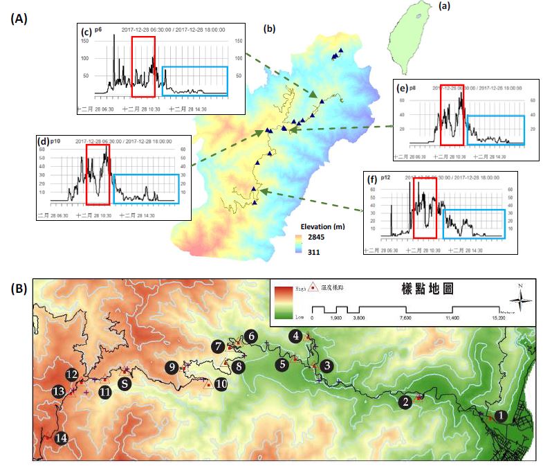
(A)本研究計畫在(a)台灣東北部(b)棲蘭山中海拔霧林架設 17 組(三角形符號)跨海拔林下日照儀組,所量測的日照輻射數據(c–f),配合地形資料,可以用來監測雲霧的時空變化。紅色框與藍色框分別表示樣方中午以及下午(有雲霧干擾時)數據(單位:µmol m-2 s-1)的變化。(B)中研院團對在中橫公路的長期生態監測樣點,並在上坡霧頻繁出現地帶架設縮時攝影系統觀測中台灣雲霧動態。
熱帶與亞熱帶山地雲霧森林(霧林)是台灣陸地分布最廣且最具特色的生態系統,也是全世界陸域生物多樣性的熱點,在近年來的研究發現,由於全球暖化造成雲霧時空動態的變異,極可能對此稀珍且脆弱的生態系統造成極大的威脅,然而,我們對於雲霧對於霧林的影響尚不清楚。本台大-中研院的創新性合作計畫,主要長遠目標是從碳、能量與水文循環以及動物行為生態的角度來瞭解到雲霧(主要為上坡霧)對於整體生態系統的影響,而過去兩年主要的工作項目是在台灣東北部棲蘭山霧林帶架設 4 個林外以及 17 個林下雲霧監測網絡,並持續研發數據分析演算法來系統化的監測每日雲霧分布,再配合中研院在中部橫貫公路沿海拔所架設的縮時攝影機所拍攝的雲霧影像資料,我們將可歸納出最適合量化台灣霧林雲霧分布的方式。本計畫的研究成果配合研究團隊已經長年持續蒐集的植物生態生理、水文、能量以及動物行為資料,將對氣候變遷對熱帶與亞熱帶霧林生態系統的衝擊有進一步的瞭解。
(A)本研究計畫在(a)台灣東北部(b)棲蘭山中海拔霧林架設 17 組(三角形符號)跨海拔林下日照儀組,所量測的日照輻射數據(c–f),配合地形資料,可以用來監測雲霧的時空變化。紅色框與藍色框分別表示樣方中午以及下午(有雲霧干擾時)數據(單位:µmol m-2 s-1)的變化。(B)中研院團對在中橫公路的長期生態監測樣點,並在上坡霧頻繁出現地帶架設縮時攝影系統觀測中台灣雲霧動態。